“The trails were a product of the pioneer days of auto travel when government took little interest in interstate roads. Most long distance trips, even by the most avid advocate of the automobile, took place in the comfort of the Nation’s railroads. Although named trails can be traced to the 1890’s, the movement began in earnest in the early 1910’s, with the National Old Trails Road (Baltimore to Los Angeles) and the Lincoln Highway setting the pattern. Boosters selected a route over existing—often, just barely existing—roads, gave it a colorful name, formed an association to promote the trail, and collected dues from businesses and towns along the way. The association published trail guides and newsletters, held annual conventions, and promoted the improvement and use of their route. The goals were to promote the road, the good roads cause, and economic opportunity for the cities and businesses along the way.” Richard F. Weingroff, Federal Highway Administration


“The Golden Belt Country The Golden Belt Road offers the shortest, most picturesque and best motor route between Kansas City and Colorado. It traverses the rich Kaw and Smoky Hill valleys, the wheat section of Kansas—the Golden Belt—and takes the most direct route over the high plains.” Golden Belt Road guidebook, 1918-1919“
“The first Kansas motor highway on which signs have been placed marking every turn is the Golden Belt Road from Kansas City to the west line of the state, where it connects with the Colorado highway to Denver and Colorado Springs. More than 350 road signs and 175 danger signs have been placed. The road signs are 12x18 inches on enameled iron with the words ‘Golden Belt Road’ in yellow letters against a blue background. The signs are to placed on iron posts painted yellow and every turn is marked by two road signs. Preceding each, three telephone poles or fence posts are marked with yellow bands to indicate a turn.”
Kit Carson County Record (Burlington, Colorado) June 12, 1912
Bypassed by the Golden Belt Road, towns along the Union Pacific Railroad from Oakley, Kansas, to Limon, Colorado, pushed for a new named highway.
Proposed names for this new “cutoff” road were:
Golden Belt Cut Off
Union Pacific Highway
Denver and Pike’s Peak Highway
Pike’s Peak Highway
Smoky Hill Trail Highway.
The latter name was proposed by the town of Hugo, Colorado. Their newspaper on January 20, 1917 noted:
“Some day, when the Sons of Colorado and the pioneer societies get around to the project, the old ‘Smoky Hill’ stage road or trail, which extends from Leavenworth, Kansas, to Denver, passing through Wallace, Kansas, Hugo, and other well-known towns, will be appropriately marked by granite monuments on the old stage station sites. . . . without any reflection on the name ‘Union Pacific’ highway, we believe, the highway should bear the name, ‘Smoky Hill Trail’ highway to perpetuate in history, the old trail made famous in early days of Colorado, the same as the ‘Santa Fe trail,’ ‘Oregon trail,’ etc.”
“Our yellow sign stands out on the highway like a lighthouse at sea. It is not beautiful or artistic, perhaps, bit it is the most reassuring comforter to the traveler ever devised.”
Percy Towne, President of the California State Automobile Association, 1917.
Hodgden House Museum Complex, Ellsworth, Kansas


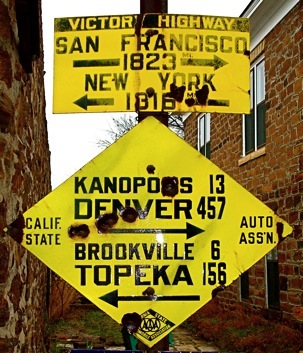
George Stanfield of Topeka, Kansas, hatched the idea of a coast-to-coast highway honoring World War I dead. The new highway association, which was incorporated on June 6, 1921, was adquarters were in Topeka. The Victory Highway ran from New York to San Francisco.

